
1850 - 1930 Census
Frederick County, Oldfield Area
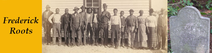
The objective of compiling the following census data was to identify the members of the small community known as Oldfield. This community, which was primarily African American, centered on present day Keys Chapel Road, in the north central portion of what often is referred to as the Liberty Election District. On a modern map, Oldfield is a roughly 1/2 square mile area northwest of the junction of Coppermine Road and Route 31 (New Windsor Road on some maps).
Initially it was not known how large this community was, nor which individuals were a part of it. Therefore, erring on the conservative side, listings were made of black households close in the census records to a known long-time household in the community, that of John and Ellen Key and later that of his son, John H. Key and wife Ella. The result is that members of several other small black communities will be found in the following table. In some cases members of communities in Libertytown, Mount Pleasant, Linganore, and Mt. Olive will be found to be included. The community of Mt. Olive needs clarification. There were (and are) a number of Mt. Olive churches and associated communities in Frederick (and Carroll) County. The one noted here is often referred to as "near New Windsor." In fact, the (no longer existing) church and cemetery are located at the top of a hill accessible only from Parsonage Lane near the east central tip of Frederick County.
It now appears that, through the decades, the Oldfield community consisted of something less than a dozen families living on or in close proximity to Keys Chapel Road. Given that censustakers generally collected and recorded information by going door to door, one might expect to find members of the Oldfield community within ± 10 household numbers of that of John and Ellen Key. It appears that John Key actually lived on Route 31 just south of its junction with Coppermine Road.
The Oldfield black community appears to have come into existence immediately following the Civil War. Some of its members, for example John H. Key, were slaves freed by the War. Others, however, appear to have been free prior to that time. One of the major objectives of this work is to fill in the details of the origins of this and other African American communities of the County.
Click on the following link to view these census data. Note that all individuals are assumed to be black unless the surname is followed by a (W). A few white households have been included in order to give additional aid in determining the geographic location of a grouping of households. The 1858 and 1873 Frederick County maps show the approximate location of many of the households at those particular times. These maps, however, do not identify which households are white and which are black.